Full Citation:
Jackson, B., Pagella, T., Sinclair, F., Orellana, B., Henshaw, A., Reynolds, B., Mcintyre, N., Wheater, H., Eycott, A. (2013). Polyscape: A GIS mapping framework providing efficient and spatially explicit landscape-scale valuation of multiple ecosystem services. Landscape and Urban Planning, 112, 74–88. doi:10.1016/j.landurbplan.2012.12.014
Background and Purpose:
“This paper introduces a GIS framework (Polyscape) designed to explore spatially explicit synergies and trade-offs amongst ecosystem services to support landscape management (from individual fields through to catchments of ca 10,000 km2 scale). Algorithms are described and results presented from a case study application within an upland Welsh catchment (Pontbren).” (p.74).
Polyscape was developed in response to:
- Evidence from international research of the need to improve the provision of regulating ecosystem services
- An understanding that policy supporting the provision of regulating ecosystem services must be implemented in a spatially-explicit context
- A recognition that local stakeholders hold valuable knowledge about the environment they live and work in, and this knowledge should be integrated into decision making processes regarding landscape level decisions
“Polyscape is designed to facilitate:
- Spatially explicit policy implementation;
- Integration of policy implementation across sectors (e.g.: water, biodiversity, agriculture, and forestry);
- Participation (and learning) by many different stakeholder groups.” (p.75)
Overview of the Polyscape GIS Framework:
Tool Description
Polyscape currently includes algorithms to explore… “current and potential impacts of land management change on a single [ecosystem service]. These are:
- Habitat networks
- Flooding
- Erosion/sediment delivery
- Carbon sequestration
- Agricultural productivity” (p.75)
Using these algorithms, Polyscape classifies elements within the landscape (ie: GIS polygons) according to their value for each of the above services on a 1 (very low value, therefore high opportunity for change) – 5 (very high value) scale. These classifications are visualized using a red-yellow-green colour scale.
An additional algorithm is used to calculate “trade-offs and co-benefits between these five ecosystem services” (p.76).
Agricultural Valuation Tool*
“The agricultural valuation tool provides a screening method to categorize land by its productivity value for farmers” (p.78). The valuation can be done either taking into account, or ignoring, current land use. Polyscape developers recognize that most farmers already possess an understanding of the productivity of their land but that this tool “serves an important purpose when it comes to considering trade-offs and synergies between services” (p.78). The tool can therefore be used to explore options to protect high value land and focus changes on marginal land.
The agricultural valuation tool requires the following input data: digital elevation model, soil information (fertility and drainage), current land use information, two or more critical slope values.
*Tools for other ecosystem services are not covered in this summary, see full paper for details about the other four ecosystem service tools.
Trade-Off Tools
As stated above, “Polyscape includes algorithms to trade the individual ecosystem services … against each other in a number of ways. [The trade-off maps developed using these algorithms] allow identification of areas where interventions provide multiple benefits and areas where intervention is clearly undesirable because existing socioeconomic or ecological value is high” (p.78).
Two-way, three-way, or four-way trade-offs can be evaluated within Polyscape in four ways:
- Additive (all services treated equally)
- Weighted additive (services are weighted with values)
- Conservative (only identifies areas with positive synergies)
- Boolean (allows a combination of additive and conservative)
Currently Polyscape can not perform an economic valuation of ecosystem services.
Case Study:
Results from a 12.5 square km case study site are presented. Figure 6 illustrates results of the analysis of agricultural productivity in four different ways. Similar analysis were performed for the four other ecosystem services.
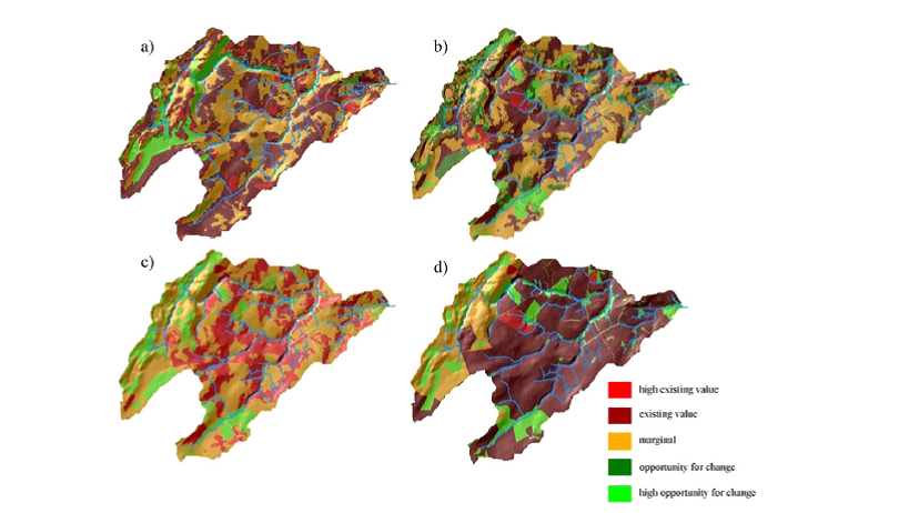
Figure 6 – Agricultural valuations. a) the categorization of the landscape into agricultural productivity categories irrespective of current land use. b) examines whether land is being under or over utilized according to the default 5-way categorization system. c) considers the same using a 3-way categorization system, and d) examines food security. From Jackson et. al. (2013), p.83
Once layers for each ecosystem service are developed using the Polyscape Framework, these layers can be pulled together using the trade-offs and synergies algorithm to identify areas “where interventions provide multiple benefits and those where intervention is undesirable due to the existing agricultural or ecological value” (p.85). Figure 7 illustrates the results of this trade-off analysis of three ecosystem services: agricultural productivity, habitat provision, and flood rise mitigation opportunities.
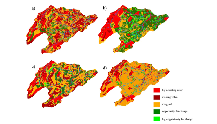
Figure 7. Polyscape trade-off layers, demonstrating how landscape decisions change when two or more decisions are traded off against each other. a) Flood mitigation verses agricultural productivity services, b) flood mitigation verses broadleaved woodland habitat services, c) agricultural productivity verses broadleaved woodland habitat services, and d) trade-offs between three services: agricultural productivity, broadleaved woodland habitat services, and flood mitigation. From Jackson et. al. (2013), p.85.